


Reynes mine de talc+ cascade

robertperello
User
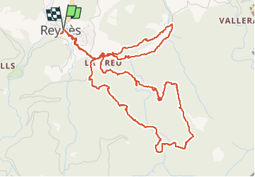

Length
8.5 km

Max alt
515 m

Uphill gradient
440 m
Km-Effort
14.4 km

Min alt
211 m

Downhill gradient
440 m
Boucle
Yes
Creation date :
2022-11-16 08:19:17.0
Updated on :
2022-11-16 14:04:33.531
2h50
Difficulty : Difficult

FREE GPS app for hiking
 SityTrail
IGN / Geographical institutes
SityTrail Plus
The world is yours!
About
Trail Other activity of 8.5 km to be discovered at Occitania, Pyrénées-Orientales, Reynès. This trail is proposed by robertperello.
Description
Randonnée agréable en sous bois
Photos


Positioning
Country:
France
Region :
Occitania
Department/Province :
Pyrénées-Orientales
Municipality :
Reynès
Location:
Unknown
Start:(Dec)
Start:(UTM)
475967 ; 4702675 (31T) N.
Comments