


reco du 23/11

guyzinz
User
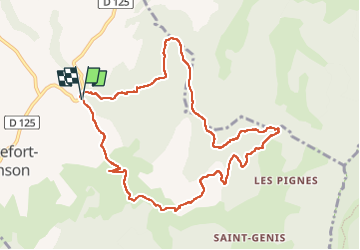

Length
10.8 km

Max alt
856 m

Uphill gradient
587 m
Km-Effort
18.7 km

Min alt
370 m

Downhill gradient
587 m
Boucle
Yes
Creation date :
2022-11-17 06:55:18.384
Updated on :
2022-11-24 14:30:57.547
3h22
Difficulty : Easy

FREE GPS app for hiking
 SityTrail
IGN / Geographical institutes
SityTrail Plus
The world is yours!
About
Trail Walking of 10.8 km to be discovered at Auvergne-Rhône-Alpes, Drôme, Rochefort-Samson. This trail is proposed by guyzinz.
Positioning
Country:
France
Region :
Auvergne-Rhône-Alpes
Department/Province :
Drôme
Municipality :
Rochefort-Samson
Location:
Unknown
Start:(Dec)
Start:(UTM)
670606 ; 4982917 (31T) N.
Comments