


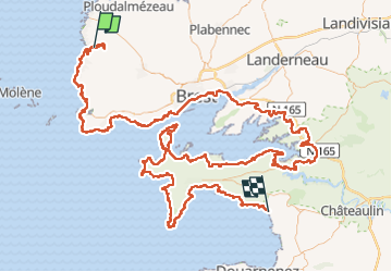
GR34 Lanildut Pentrez 253km

thonyc
User GUIDE

Length
253 km

Max alt
129 m

Uphill gradient
5020 m
Km-Effort
320 km

Min alt
-5 m

Downhill gradient
5030 m
Boucle
No
Creation date :
2022-11-17 15:38:42.697
Updated on :
2022-11-17 16:26:32.713
79h00
Difficulty : Difficult

FREE GPS app for hiking
 SityTrail
IGN / Geographical institutes
SityTrail Plus
The world is yours!
About
Trail On foot of 253 km to be discovered at Brittany, Finistère, Lanildut. This trail is proposed by thonyc.
Positioning
Country:
France
Region :
Brittany
Department/Province :
Finistère
Municipality :
Lanildut
Location:
Unknown
Start:(Dec)
Start:(UTM)
370976 ; 5370440 (30U) N.
Comments