


barentin

dedejojo
User
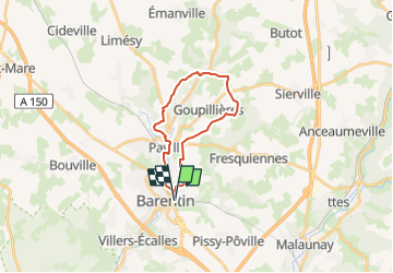

Length
18.2 km

Max alt
158 m

Uphill gradient
291 m
Km-Effort
22 km

Min alt
46 m

Downhill gradient
292 m
Boucle
Yes
Creation date :
2022-11-19 08:42:39.902
Updated on :
2022-11-19 08:43:19.279
5h01
Difficulty : Very difficult

FREE GPS app for hiking
 SityTrail
IGN / Geographical institutes
SityTrail Plus
The world is yours!
About
Trail Walking of 18.2 km to be discovered at Normandy, Seine-Maritime, Barentin. This trail is proposed by dedejojo.
Positioning
Country:
France
Region :
Normandy
Department/Province :
Seine-Maritime
Municipality :
Barentin
Location:
Unknown
Start:(Dec)
Start:(UTM)
352309 ; 5490153 (31U) N.
Comments