


Boucle vers parc des Charmilles

sebastienu
User
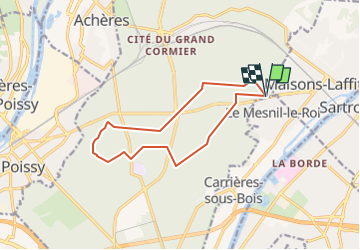

Length
11.6 km

Max alt
83 m

Uphill gradient
114 m
Km-Effort
13.1 km

Min alt
49 m

Downhill gradient
115 m
Boucle
Yes
Creation date :
2022-11-19 21:52:29.756
Updated on :
2022-11-19 21:58:27.429
3h06
Difficulty : Difficult

FREE GPS app for hiking
 SityTrail
IGN / Geographical institutes
SityTrail Plus
The world is yours!
About
Trail Walking of 11.6 km to be discovered at Ile-de-France, Yvelines, Saint-Germain-en-Laye. This trail is proposed by sebastienu.
Description
Départ sur parking en lisière sur D308 en face Aldi, boucle vers parc des Charmille.
2 traversées de D184 : Croix de Noaille et route de Saint Hubert
Positioning
Country:
France
Region :
Ile-de-France
Department/Province :
Yvelines
Municipality :
Saint-Germain-en-Laye
Location:
Saint-Germain-en-Laye
Start:(Dec)
Start:(UTM)
436050 ; 5421518 (31U) N.
Comments