Cirque de Labeil

nanie
User
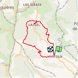

Length
14.8 km

Max alt
776 m

Uphill gradient
618 m
Km-Effort
23 km

Min alt
301 m

Downhill gradient
617 m
Boucle
Yes
Creation date :
2014-12-10 00:00:00.0
Updated on :
2014-12-10 00:00:00.0
4h47
Difficulty : Medium

FREE GPS app for hiking
 SityTrail
IGN / Geographical institutes
SityTrail Plus
The world is yours!
About
Trail Walking of 14.8 km to be discovered at Occitania, Hérault, Lauroux. This trail is proposed by nanie.
Description
Trés belle randonnée
Départ assez raide mais à partir de Labeil facile
Photos


Positioning
Country:
France
Region :
Occitania
Department/Province :
Hérault
Municipality :
Lauroux
Location:
Unknown
Start:(Dec)
Start:(UTM)
523274 ; 4847277 (31T) N.
Comments