


VAUVERT

Dupuybadonniere
User
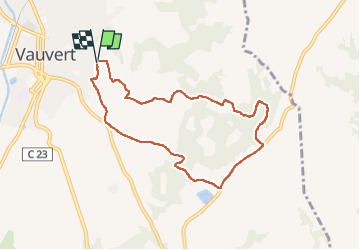

Length
8 km

Max alt
86 m

Uphill gradient
85 m
Km-Effort
9.2 km

Min alt
48 m

Downhill gradient
85 m
Boucle
Yes
Creation date :
2022-11-22 12:58:18.646
Updated on :
2022-11-22 14:59:45.828
1h44
Difficulty : Medium

FREE GPS app for hiking
 SityTrail
IGN / Geographical institutes
SityTrail Plus
The world is yours!
About
Trail Walking of 8 km to be discovered at Occitania, Gard, Vauvert. This trail is proposed by Dupuybadonniere.
Positioning
Country:
France
Region :
Occitania
Department/Province :
Gard
Municipality :
Vauvert
Location:
Unknown
Start:(Dec)
Start:(UTM)
603526 ; 4838401 (31T) N.
Comments