


Aix-la-Chapelle

mumu.larandonneuse
User GUIDE
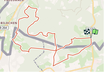

Length
13 km

Max alt
345 m

Uphill gradient
231 m
Km-Effort
16.1 km

Min alt
244 m

Downhill gradient
232 m
Boucle
Yes
Creation date :
2022-11-23 14:21:34.61
Updated on :
2022-11-23 14:26:17.666
3h39
Difficulty : Easy

FREE GPS app for hiking
 SityTrail
IGN / Geographical institutes
SityTrail Plus
The world is yours!
About
Trail Walking of 13 km to be discovered at North Rhine-Westphalia, Städteregion Aachen, Aachen. This trail is proposed by mumu.larandonneuse.
Description
Une randonnée transfrontalière 🇩🇪🇧🇪.
ℹ www.aachen.de/wandern
📌🅿️ Köpfchen, Eupener Strabe
➡️ Points-noeuds 59 54 52 51 48 53 65 71 54 77 56 59.
Positioning
Country:
Germany
Region :
North Rhine-Westphalia
Department/Province :
Städteregion Aachen
Municipality :
Aachen
Location:
Aachen-Mitte
Start:(Dec)
Start:(UTM)
294602 ; 5623239 (32U) N.
Comments
06/03/23 Superbe parcours entièrement boisé hormis les passages à Hergenrath et Hauset. Fait avec Luna. A refaire avec de la neige ❄☃️ 11/01/25 : Magnifique avec la neige