Trail Walking Wattwiller - SityTrail - SityTrail - Wattwiller-Berrwiller 2 - Photo

SityTrail - SityTrail - Wattwiller-Berrwiller 2

 E.BURCK
E.BURCK

User

© OpenStreetMap contributors
Length
Length
11.2 km
Max alt
Max alt
482 m
Uphill gradient
Uphill gradient
269 m
Km-Effort
Km-Effort  
14.8 km
Min alt
Min alt
257 m
Downhill gradient
Downhill gradient
269 m
Boucle
Boucle
Yes
Creation date :
2022-11-24 09:11:59.908
Updated on :
2024-02-12 09:04:02.048

(1 Reviews)

Walking
Walking
3h22
Difficulty : Easy

Scan this QR Code to open this trail in the SityTrail application

FREE GPS app for hiking

Logo SityTrail SityTrail

IGN / Geographical institutes

Download SityTrail from the App Store Download SityTrail from Google Play

Logo SityTrail SityTrail World

The world is yours!

Download SityTrail from the App Store Download SityTrail from Google Play Download SityTrail on Huawei AppGallery

About

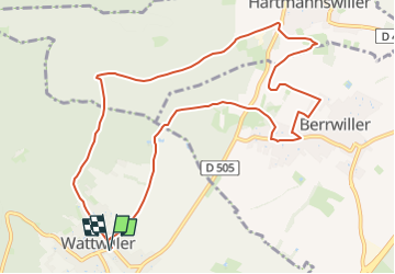
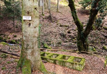
Trail Walking of 11.2 km to be discovered at Grand Est, Haut-Rhin, Wattwiller. This trail is proposed by E.BURCK.

Description

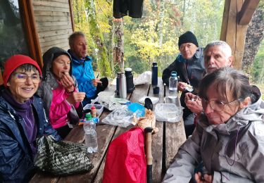
Balade facile et connue au pied des Vosges (270 m de dénivelé et 11.2 km), seul le lieu de restauration est modifié.
J'attends vos réponses  avant mardi 12 heures pour réserver le restaurant.      

ACCÈS :  
   -Wattwiller : aller dans la rue du Général de Gaulle. (voir plan)
     
PARKING:
   -au croisement de la rue du Général de Gaulle avec la rue de la Cantine , le parking de la Salle Krafft.
47.836526 ,   7.182469   ou        
N 47°50'11.5"      E  007°10'56.9"  
                                     
RESTAURATION :  Restaurant Au Vieil Armand, 120 rue Principale à Berrwiller.
Tél.: 03 89 76 73 23

Elevation profile

Positioning

Country:
France
Region :
Grand Est
Department/Province :
Haut-Rhin
Municipality :
Wattwiller
Location:
Unknown
Start:(UTM)
364001 ; 5299722 (32T) N.

Comments

Please log in to post a review or rate the element


Trails nearby

Trail Walking Soultz-Haut-Rhin - Hartmannswillerkopf - Circuit découverte - Photo
Walking
VacheKiri67

Walking

Easy
(1)
Soultz-Haut-Rhin, Grand Est, Haut-Rhin, France
3.6 km | 5.2 km-effort
1h 46min
Yes
Trail Walking Soultz-Haut-Rhin - Hartmannswillerkopf - Circuit anneau bleu - Photo
Walking
VacheKiri67

Walking

Medium
(1)
Soultz-Haut-Rhin, Grand Est, Haut-Rhin, France
3.7 km | 5.9 km-effort
1h 37min
Yes
Trail Other activity Steinbach - lac du ballon - Photo
Other activity
rodabruna

Other activity

Very easy
(1)
Steinbach, Grand Est, Haut-Rhin, France
33 km | 64 km-effort
5h 1min
No
Trail Trail Wattwiller - The History Ultra - stage 1 - Photo
Trail
Olivier Houette

Trail

Very easy
(1)
Wattwiller, Grand Est, Haut-Rhin, France
28 km | 48 km-effort
Unknown
No
Trail Walking Uffholtz - Molkenrain 1 - Photo
Walking
regisbodilis

Walking

Difficult
(1)
Uffholtz, Grand Est, Haut-Rhin, France
15.4 km | 26 km-effort
4h 0min
Yes
Trail Walking Steinbach - Rando CLAS du 02/11/2023 - Photo
Walking
boubou68

Walking

Very difficult
Steinbach, Grand Est, Haut-Rhin, France
17.7 km | 27 km-effort
4h 35min
Yes
Trail Walking Steinbach - Rando Marcheurs du 03/07/2023 par ALAIN - Photo
Walking
boubou68

Walking

Very difficult
Steinbach, Grand Est, Haut-Rhin, France
20 km | 34 km-effort
5h 1min
Yes
Trail Walking Wattwiller - Wattwiller - Domaine du Hirtz (30/03/2023) - Photo
Walking
Richard68500

Walking

Easy
Wattwiller, Grand Est, Haut-Rhin, France
6.1 km | 9.9 km-effort
2h 7min
Yes
Trail Walking Soultz-Haut-Rhin - Rando avec 0mar et Mouloud..18/02/2023 - Photo
Walking
boubou68

Walking

Very difficult
Soultz-Haut-Rhin, Grand Est, Haut-Rhin, France
12 km | 20 km-effort
3h 9min
Yes


Close
My subscriptions