


Boucle Yerres - Réveillon

jeanmarcMasson
User GUIDE
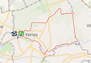

Length
10.4 km

Max alt
119 m

Uphill gradient
134 m
Km-Effort
12.2 km

Min alt
36 m

Downhill gradient
134 m
Boucle
Yes
Creation date :
2022-11-24 13:34:25.271
Updated on :
2022-11-24 13:59:30.579
2h47
Difficulty : Difficult

FREE GPS app for hiking
 SityTrail
IGN / Geographical institutes
SityTrail Plus
The world is yours!
About
Trail Walking of 10.4 km to be discovered at Ile-de-France, Essonne, Yerres. This trail is proposed by jeanmarcMasson.
Positioning
Country:
France
Region :
Ile-de-France
Department/Province :
Essonne
Municipality :
Yerres
Location:
Unknown
Start:(Dec)
Start:(UTM)
461656 ; 5395879 (31U) N.
Comments