


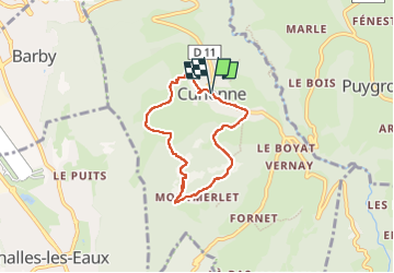
curienne

papou73
User

Length
5.8 km

Max alt
859 m

Uphill gradient
188 m
Km-Effort
8.3 km

Min alt
705 m

Downhill gradient
191 m
Boucle
Yes
Creation date :
2022-11-28 12:12:02.593
Updated on :
2022-11-28 14:03:24.749
1h35
Difficulty : Medium

FREE GPS app for hiking
 SityTrail
IGN / Geographical institutes
SityTrail Plus
The world is yours!
About
Trail Walking of 5.8 km to be discovered at Auvergne-Rhône-Alpes, Savoy, Curienne. This trail is proposed by papou73.
Positioning
Country:
France
Region :
Auvergne-Rhône-Alpes
Department/Province :
Savoy
Municipality :
Curienne
Location:
Unknown
Start:(Dec)
Start:(UTM)
266592 ; 5050222 (32T) N.
Comments