


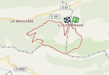
circuit de l'Audibergue

alainfauvet
User

Length
8.5 km

Max alt
1636 m

Uphill gradient
443 m
Km-Effort
14.4 km

Min alt
1337 m

Downhill gradient
440 m
Boucle
Yes
Creation date :
2022-11-28 14:26:29.146
Updated on :
2022-11-28 14:30:43.404
3h16
Difficulty : Difficult

FREE GPS app for hiking
 SityTrail
IGN / Geographical institutes
SityTrail Plus
The world is yours!
About
Trail Walking of 8.5 km to be discovered at Provence-Alpes-Côte d'Azur, Maritime Alps, Andon. This trail is proposed by alainfauvet.
Description
Départ depuis le parking de l'Audibergue station ou celui de la Moulière station
Positioning
Country:
France
Region :
Provence-Alpes-Côte d'Azur
Department/Province :
Maritime Alps
Municipality :
Andon
Location:
Unknown
Start:(Dec)
Start:(UTM)
321900 ; 4847530 (32T) N.
Comments