


4_4_261122_73

d.rognon
User
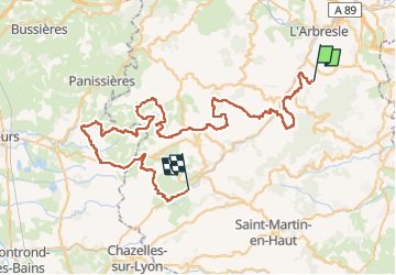

Length
77 km

Max alt
751 m

Uphill gradient
2254 m
Km-Effort
107 km

Min alt
251 m

Downhill gradient
2202 m
Boucle
No
Creation date :
2022-11-26 08:00:37.129
Updated on :
2022-11-29 13:24:46.363
4h25
Difficulty : Very easy

FREE GPS app for hiking
 SityTrail
IGN / Geographical institutes
SityTrail Plus
The world is yours!
About
Trail 4x4 of 77 km to be discovered at Auvergne-Rhône-Alpes, Rhône, Saint-Pierre-la-Palud. This trail is proposed by d.rognon.
Positioning
Country:
France
Region :
Auvergne-Rhône-Alpes
Department/Province :
Rhône
Municipality :
Saint-Pierre-la-Palud
Location:
Unknown
Start:(Dec)
Start:(UTM)
625105 ; 5072244 (31T) N.
Comments