


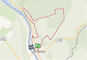
Tracé actuel: 27 OCT 2015 13:51

ZAMBAUX
User

Length
9.6 km

Max alt
390 m

Uphill gradient
225 m
Km-Effort
12.6 km

Min alt
217 m

Downhill gradient
225 m
Boucle
Yes
Creation date :
2022-11-29 17:44:18.821
Updated on :
2022-11-29 17:45:24.054
2h51
Difficulty : Difficult

FREE GPS app for hiking
 SityTrail
IGN / Geographical institutes
SityTrail Plus
The world is yours!
About
Trail Walking of 9.6 km to be discovered at Grand Est, Meurthe-et-Moselle, Maron. This trail is proposed by ZAMBAUX.
Positioning
Country:
France
Region :
Grand Est
Department/Province :
Meurthe-et-Moselle
Municipality :
Maron
Location:
Unknown
Start:(Dec)
Start:(UTM)
282250 ; 5391176 (32U) N.
Comments