Trail Walking Saint-Vallier - La Croix Racot - Photo
© OpenStreetMap contributors
Length
Length
4.4 km
Max alt
Max alt
370 m
Uphill gradient
Uphill gradient
95 m
Km-Effort
Km-Effort  
5.7 km
Min alt
Min alt
311 m
Downhill gradient
Downhill gradient
96 m
Boucle
Boucle
Yes
Creation date :
2022-12-01 11:15:05.985
Updated on :
2022-12-01 11:18:33.471

(0 Reviews)

Walking
Walking
1h17
Difficulty : Easy

Scan this QR Code to open this trail in the SityTrail application

FREE GPS app for hiking

Logo SityTrail SityTrail

IGN / Geographical institutes

Download SityTrail from the App Store Download SityTrail from Google Play

Logo SityTrail SityTrail World

The world is yours!

Download SityTrail from the App Store Download SityTrail from Google Play Download SityTrail on Huawei AppGallery

About

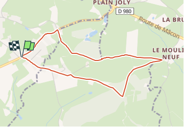
Trail Walking of 4.4 km to be discovered at Bourgogne-Franche-Comté, Saône-et-Loire, Saint-Vallier. This trail is proposed by Petit Marcheur.

Description

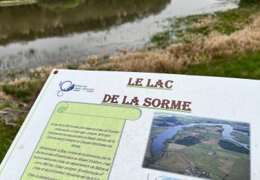
Au départ du "River Boat"

Elevation profile

Positioning

Country:
France
Region :
Bourgogne-Franche-Comté
Department/Province :
Saône-et-Loire
Municipality :
Saint-Vallier
Location:
Unknown
Start:(UTM)
607003 ; 5167004 (31T) N.

Trails nearby

Trail Walking Marigny - Marigny 16 - Photo
Walking
jlbard

Walking

Easy
(1)
Marigny, Bourgogne-Franche-Comté, Saône-et-Loire, France
29 km | 38 km-effort
6h 34min
Yes
Trail Mountain bike Montceau-les-Mines - Randonnée VTT , barrage de la Sorme et ces environs  - Photo
Mountain bike
Samolo71

Mountain bike

Medium
Montceau-les-Mines, Bourgogne-Franche-Comté, Saône-et-Loire, France
30 km | 36 km-effort
2h 30min
Yes
Trail Walking Gourdon - Gourdon 11km - Photo
Walking
jcbossant

Walking

Difficult
(1)
Gourdon, Bourgogne-Franche-Comté, Saône-et-Loire, France
10.7 km | 14.8 km-effort
3h 21min
Yes
Trail Walking Pouilloux - POUILLOUX LA PRERE - Photo
Walking
Bret

Walking

Medium
(1)
Pouilloux, Bourgogne-Franche-Comté, Saône-et-Loire, France
9.7 km | 10.9 km-effort
2h 28min
Yes
Trail Walking Marigny - marigny 15 mai 2022 - Photo
Walking
Noisette@

Walking

Easy
Marigny, Bourgogne-Franche-Comté, Saône-et-Loire, France
21 km | 26 km-effort
4h 26min
Yes
Trail Road bike Montceau-les-Mines - sortie velo autour de marcilly - Photo
Road bike

Road bike

Very difficult
Montceau-les-Mines, Bourgogne-Franche-Comté, Saône-et-Loire, France
92 km | 111 km-effort
6h 42min
Yes
Trail Walking Marigny - 20240428_Marigny - Ragy - Les Brosses - Le Douvent - Photo
Walking
galain

Walking

Easy
Marigny, Bourgogne-Franche-Comté, Saône-et-Loire, France
10.7 km | 13.3 km-effort
3h 1min
Yes
Trail Walking Saint-Romain-sous-Gourdon - St Romain Sous Gourdon - Photo
Walking
GP71

Walking

Medium
Saint-Romain-sous-Gourdon, Bourgogne-Franche-Comté, Saône-et-Loire, France
12.5 km | 17.2 km-effort
2h 57min
Yes
Trail Mountain bike Montceau-les-Mines - Montceau / Uchon / La Tagnière  - Photo
Mountain bike
Samolo71

Mountain bike

Very difficult
Montceau-les-Mines, Bourgogne-Franche-Comté, Saône-et-Loire, France
49 km | 61 km-effort
4h 15min
Yes


Close
My subscriptions