


sainte consorce

Jean-Marc C
User
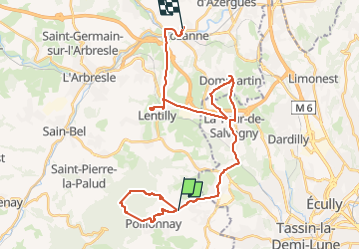

Length
34 km

Max alt
643 m

Uphill gradient
689 m
Km-Effort
44 km

Min alt
198 m

Downhill gradient
818 m
Boucle
No
Creation date :
2022-12-01 08:10:17.438
Updated on :
2022-12-01 14:31:36.15
6h02
Difficulty : Very difficult

FREE GPS app for hiking
 SityTrail
IGN / Geographical institutes
SityTrail Plus
The world is yours!
About
Trail Walking of 34 km to be discovered at Auvergne-Rhône-Alpes, Rhône, Pollionnay. This trail is proposed by Jean-Marc C.
Description
vers la Croix du Banc
Positioning
Country:
France
Region :
Auvergne-Rhône-Alpes
Department/Province :
Rhône
Municipality :
Pollionnay
Location:
Unknown
Start:(Dec)
Start:(UTM)
630455 ; 5070099 (31T) N.
Comments