SityTrail - Téléthon.2022.Circuit A

jeanmarcMasson
User GUIDE
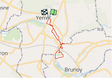

Length
5.5 km

Max alt
53 m

Uphill gradient
40 m
Km-Effort
6.1 km

Min alt
37 m

Downhill gradient
44 m
Boucle
Yes
Creation date :
2022-12-01 19:57:00.565
Updated on :
2022-12-08 14:12:52.376
1h23
Difficulty : Medium

FREE GPS app for hiking
 SityTrail
IGN / Geographical institutes
SityTrail Plus
The world is yours!
About
Trail Walking of 5.5 km to be discovered at Ile-de-France, Essonne, Yerres. This trail is proposed by jeanmarcMasson.
Positioning
Country:
France
Region :
Ile-de-France
Department/Province :
Essonne
Municipality :
Yerres
Location:
Unknown
Start:(Dec)
Start:(UTM)
462559 ; 5396040 (31U) N.
Comments