


SityTrail - Téléthon.03122022

jeanmarcMasson
User GUIDE
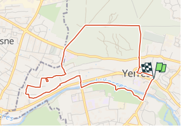

Length
5.3 km

Max alt
121 m

Uphill gradient
100 m
Km-Effort
6.6 km

Min alt
37 m

Downhill gradient
102 m
Boucle
Yes
Creation date :
2022-12-01 19:57:56.426
Updated on :
2022-12-01 20:04:34.296
1h30
Difficulty : Medium

FREE GPS app for hiking
 SityTrail
IGN / Geographical institutes
SityTrail Plus
The world is yours!
About
Trail Walking of 5.3 km to be discovered at Ile-de-France, Essonne, Yerres. This trail is proposed by jeanmarcMasson.
Positioning
Country:
France
Region :
Ile-de-France
Department/Province :
Essonne
Municipality :
Yerres
Location:
Unknown
Start:(Dec)
Start:(UTM)
462556 ; 5396033 (31U) N.
Comments