


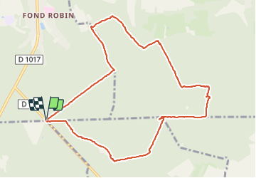
Le Mont Pagnotte_trace_10,4 km

Pousscailleux
User

Length
10.4 km

Max alt
232 m

Uphill gradient
237 m
Km-Effort
13.6 km

Min alt
99 m

Downhill gradient
237 m
Boucle
Yes
Creation date :
2014-12-10 00:00:00.0
Updated on :
2014-12-10 00:00:00.0
3h14
Difficulty : Medium

FREE GPS app for hiking
 SityTrail
IGN / Geographical institutes
SityTrail Plus
The world is yours!
About
Trail Walking of 10.4 km to be discovered at Hauts-de-France, Oise, Pont-Sainte-Maxence. This trail is proposed by Pousscailleux.
Description
Départ du Poteau du Grand Maître.
Positioning
Country:
France
Region :
Hauts-de-France
Department/Province :
Oise
Municipality :
Pont-Sainte-Maxence
Location:
Unknown
Start:(Dec)
Start:(UTM)
471410 ; 5458399 (31U) N.
Comments