


Disons

raygautier
User
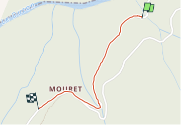

Length
639 m

Max alt
251 m

Uphill gradient
37 m
Km-Effort
1 km

Min alt
199 m

Downhill gradient
6 m
Boucle
No
Creation date :
2022-12-05 09:15:03.0
Updated on :
2022-12-05 13:37:33.138
4h17
Difficulty : Easy

FREE GPS app for hiking
 SityTrail
IGN / Geographical institutes
SityTrail Plus
The world is yours!
About
Trail Walking of 639 m to be discovered at Auvergne-Rhône-Alpes, Ardèche, Tournon-sur-Rhône. This trail is proposed by raygautier.
Positioning
Country:
France
Region :
Auvergne-Rhône-Alpes
Department/Province :
Ardèche
Municipality :
Tournon-sur-Rhône
Location:
Unknown
Start:(Dec)
Start:(UTM)
640419 ; 4990360 (31T) N.
Comments