


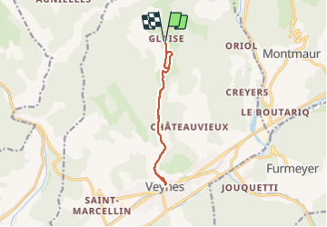
Veynes - Glaise A/R

rigol05
User

Length
10.3 km

Max alt
1178 m

Uphill gradient
343 m
Km-Effort
14.9 km

Min alt
840 m

Downhill gradient
343 m
Boucle
Yes
Creation date :
2022-12-06 13:19:36.717
Updated on :
2023-08-13 15:53:56.348
3h22
Difficulty : Medium

FREE GPS app for hiking
 SityTrail
IGN / Geographical institutes
SityTrail Plus
The world is yours!
About
Trail On foot of 10.3 km to be discovered at Provence-Alpes-Côte d'Azur, Hautes-Alpes, Veynes. This trail is proposed by rigol05.
Description
Itinéraire exclusivement sur route
Positioning
Country:
France
Region :
Provence-Alpes-Côte d'Azur
Department/Province :
Hautes-Alpes
Municipality :
Veynes
Location:
Unknown
Start:(Dec)
Start:(UTM)
724270 ; 4939517 (31T) N.
Comments