


Olne montagnard /froidbermont/escaliers

Laurence Lallemand
User
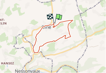

Length
5.8 km

Max alt
252 m

Uphill gradient
129 m
Km-Effort
7.5 km

Min alt
127 m

Downhill gradient
129 m
Boucle
Yes
Creation date :
2022-12-07 19:57:41.687
Updated on :
2022-12-07 19:57:42.935
1h42
Difficulty : Medium

FREE GPS app for hiking
 SityTrail
IGN / Geographical institutes
SityTrail Plus
The world is yours!
About
Trail Walking of 5.8 km to be discovered at Wallonia, Liège, Olne. This trail is proposed by Laurence Lallemand.
Positioning
Country:
Belgium
Region :
Wallonia
Department/Province :
Liège
Municipality :
Olne
Location:
Unknown
Start:(Dec)
Start:(UTM)
694862 ; 5608013 (31U) N.
Comments