


aiguillon

Francinedu
User
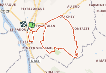

Length
10.5 km

Max alt
165 m

Uphill gradient
255 m
Km-Effort
13.9 km

Min alt
33 m

Downhill gradient
255 m
Boucle
Yes
Creation date :
2022-12-09 08:26:16.987
Updated on :
2022-12-09 10:49:42.2
2h09
Difficulty : Difficult

FREE GPS app for hiking
 SityTrail
IGN / Geographical institutes
SityTrail Plus
The world is yours!
About
Trail Walking of 10.5 km to be discovered at New Aquitaine, Lot-et-Garonne, Aiguillon. This trail is proposed by Francinedu.
Positioning
Country:
France
Region :
New Aquitaine
Department/Province :
Lot-et-Garonne
Municipality :
Aiguillon
Location:
Unknown
Start:(Dec)
Start:(UTM)
287349 ; 4906496 (31T) N.
Comments