


Verchenu

raygautier
User
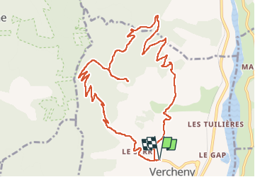

Length
13.4 km

Max alt
984 m

Uphill gradient
609 m
Km-Effort
22 km

Min alt
427 m

Downhill gradient
607 m
Boucle
Yes
Creation date :
2022-12-11 07:59:08.0
Updated on :
2022-12-11 13:12:27.487
3h41
Difficulty : Very difficult

FREE GPS app for hiking
 SityTrail
IGN / Geographical institutes
SityTrail Plus
The world is yours!
About
Trail Walking of 13.4 km to be discovered at Auvergne-Rhône-Alpes, Drôme, Vercheny. This trail is proposed by raygautier.
Positioning
Country:
France
Region :
Auvergne-Rhône-Alpes
Department/Province :
Drôme
Municipality :
Vercheny
Location:
Unknown
Start:(Dec)
Start:(UTM)
678319 ; 4953327 (31T) N.
Comments