


Bassens-G1bis-13-12-22

papou73
User
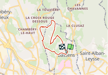

Length
6.2 km

Max alt
565 m

Uphill gradient
330 m
Km-Effort
10.6 km

Min alt
316 m

Downhill gradient
331 m
Boucle
Yes
Creation date :
2022-12-12 12:03:16.782
Updated on :
2022-12-12 14:33:54.738
2h30
Difficulty : Medium

FREE GPS app for hiking
 SityTrail
IGN / Geographical institutes
SityTrail Plus
The world is yours!
About
Trail Walking of 6.2 km to be discovered at Auvergne-Rhône-Alpes, Savoy, Bassens. This trail is proposed by papou73.
Positioning
Country:
France
Region :
Auvergne-Rhône-Alpes
Department/Province :
Savoy
Municipality :
Bassens
Location:
Unknown
Start:(Dec)
Start:(UTM)
729420 ; 5051833 (31T) N.
Comments