croix de chamrousse-refuge de la pra en aller retour

maupassant38
User
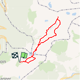

Length
14.4 km

Max alt
2279 m

Uphill gradient
837 m
Km-Effort
26 km

Min alt
1877 m

Downhill gradient
840 m
Boucle
Yes
Creation date :
2019-02-22 22:31:57.153
Updated on :
2019-02-22 22:31:57.166
5h11
Difficulty : Medium

FREE GPS app for hiking
 SityTrail
IGN / Geographical institutes
SityTrail Plus
The world is yours!
About
Trail Walking of 14.4 km to be discovered at Auvergne-Rhône-Alpes, Isère, Chamrousse. This trail is proposed by maupassant38.
Positioning
Country:
France
Region :
Auvergne-Rhône-Alpes
Department/Province :
Isère
Municipality :
Chamrousse
Location:
Unknown
Start:(Dec)
Start:(UTM)
728264 ; 5001020 (31T) N.
Comments