


Etape 2

geranimo
User
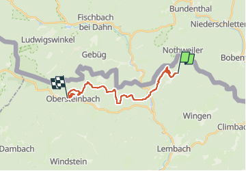

Length
16.1 km

Max alt
542 m

Uphill gradient
675 m
Km-Effort
25 km

Min alt
206 m

Downhill gradient
770 m
Boucle
No
Creation date :
2022-12-13 18:29:34.311
Updated on :
2022-12-30 19:25:09.409
5h49
Difficulty : Medium

FREE GPS app for hiking
 SityTrail
IGN / Geographical institutes
SityTrail Plus
The world is yours!
About
Trail Walking of 16.1 km to be discovered at Grand Est, Bas-Rhin, Wingen. This trail is proposed by geranimo.
Positioning
Country:
France
Region :
Grand Est
Department/Province :
Bas-Rhin
Municipality :
Wingen
Location:
Unknown
Start:(Dec)
Start:(UTM)
411861 ; 5434063 (32U) N.
Comments