


GR470 Etape Pont d'Alleyras / Chapeauroux

Guy Laurent
User
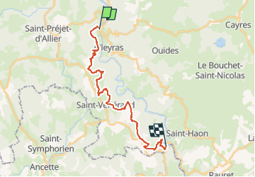

Length
22 km

Max alt
1070 m

Uphill gradient
801 m
Km-Effort
32 km

Min alt
654 m

Downhill gradient
715 m
Boucle
No
Creation date :
2022-12-14 10:17:29.429
Updated on :
2022-12-14 10:20:30.085
7h21
Difficulty : Very difficult

FREE GPS app for hiking
 SityTrail
IGN / Geographical institutes
SityTrail Plus
The world is yours!
About
Trail Walking of 22 km to be discovered at Auvergne-Rhône-Alpes, Haute-Loire, Alleyras. This trail is proposed by Guy Laurent.
Positioning
Country:
France
Region :
Auvergne-Rhône-Alpes
Department/Province :
Haute-Loire
Municipality :
Alleyras
Location:
Unknown
Start:(Dec)
Start:(UTM)
553114 ; 4974158 (31T) N.
Comments