


la fin d'un beau tour

CDSM 55
User

Length
1.3 km

Max alt
221 m

Uphill gradient
9 m
Km-Effort
1.5 km

Min alt
213 m

Downhill gradient
9 m
Boucle
No
Creation date :
2022-12-19 15:42:08.937
Updated on :
2022-12-19 16:00:31.972
13m
Difficulty : Easy

FREE GPS app for hiking
 SityTrail
IGN / Geographical institutes
SityTrail Plus
The world is yours!
About
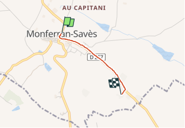
Trail Walking of 1.3 km to be discovered at Occitania, Gers, Monferran-Savès. This trail is proposed by CDSM 55.
Positioning
Country:
France
Region :
Occitania
Department/Province :
Gers
Municipality :
Monferran-Savès
Location:
Unknown
Start:(Dec)
Start:(UTM)
337097 ; 4829270 (31T) N.
Comments
dommage que le téléchargement n'a pas fonctionné, il manque 11 km !!