


Etape 3

geranimo
User
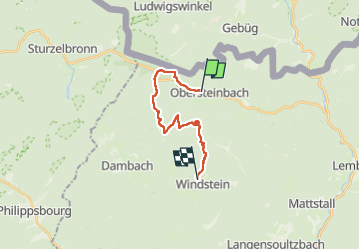

Length
14.3 km

Max alt
524 m

Uphill gradient
530 m
Km-Effort
21 km

Min alt
245 m

Downhill gradient
453 m
Boucle
No
Creation date :
2022-12-20 15:10:05.319
Updated on :
2022-12-20 15:15:03.213
4h47
Difficulty : Medium

FREE GPS app for hiking
 SityTrail
IGN / Geographical institutes
SityTrail Plus
The world is yours!
About
Trail Walking of 14.3 km to be discovered at Grand Est, Bas-Rhin, Obersteinbach. This trail is proposed by geranimo.
Positioning
Country:
France
Region :
Grand Est
Department/Province :
Bas-Rhin
Municipality :
Obersteinbach
Location:
Unknown
Start:(Dec)
Start:(UTM)
403743 ; 5432396 (32U) N.
Comments