


Balsiege /Les Fons/Causse de Mende

tyntyn
User
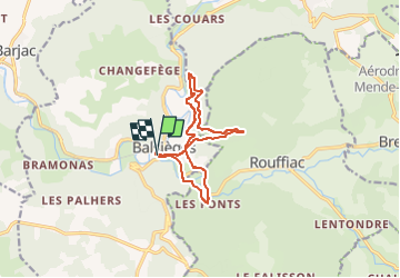

Length
12 km

Max alt
940 m

Uphill gradient
403 m
Km-Effort
17.4 km

Min alt
677 m

Downhill gradient
400 m
Boucle
Yes
Creation date :
2022-12-22 15:06:52.653
Updated on :
2022-12-22 15:06:54.029
3h57
Difficulty : Medium

FREE GPS app for hiking
 SityTrail
IGN / Geographical institutes
SityTrail Plus
The world is yours!
About
Trail Walking of 12 km to be discovered at Occitania, Lozère, Balsièges. This trail is proposed by tyntyn.
Positioning
Country:
France
Region :
Occitania
Department/Province :
Lozère
Municipality :
Balsièges
Location:
Unknown
Start:(Dec)
Start:(UTM)
536239 ; 4925435 (31T) N.
Comments