


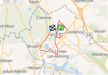
Antoing

albert318
User

Length
12.4 km

Max alt
50 m

Uphill gradient
87 m
Km-Effort
13.6 km

Min alt
12 m

Downhill gradient
87 m
Boucle
Yes
Creation date :
2014-12-10 00:00:00.0
Updated on :
2014-12-10 00:00:00.0
3h41
Difficulty : Unknown

FREE GPS app for hiking
 SityTrail
IGN / Geographical institutes
SityTrail Plus
The world is yours!
About
Trail Other activity of 12.4 km to be discovered at Wallonia, Hainaut, Antoing. This trail is proposed by albert318.
Positioning
Country:
Belgium
Region :
Wallonia
Department/Province :
Hainaut
Municipality :
Antoing
Location:
Antoing
Start:(Dec)
Start:(UTM)
532056 ; 5601651 (31U) N.
Comments