


tracés mussipontaine p4

nouga
User
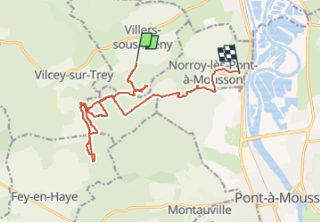

Length
15.6 km

Max alt
380 m

Uphill gradient
344 m
Km-Effort
20 km

Min alt
195 m

Downhill gradient
418 m
Boucle
No
Creation date :
2022-12-24 08:29:49.581
Updated on :
2022-12-24 12:22:28.84
2h51
Difficulty : Medium

FREE GPS app for hiking
 SityTrail
IGN / Geographical institutes
SityTrail Plus
The world is yours!
About
Trail Mountain bike of 15.6 km to be discovered at Grand Est, Meurthe-et-Moselle, Villers-sous-Prény. This trail is proposed by nouga.
Positioning
Country:
France
Region :
Grand Est
Department/Province :
Meurthe-et-Moselle
Municipality :
Villers-sous-Prény
Location:
Unknown
Start:(Dec)
Start:(UTM)
719509 ; 5424795 (31U) N.
Comments