


charnay

Jean-Marc C
User
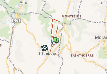

Length
3.5 km

Max alt
449 m

Uphill gradient
50 m
Km-Effort
4.3 km

Min alt
401 m

Downhill gradient
76 m
Boucle
No
Creation date :
2022-12-25 15:45:53.826
Updated on :
2022-12-25 17:08:40.169
1h22
Difficulty : Easy

FREE GPS app for hiking
 SityTrail
IGN / Geographical institutes
SityTrail Plus
The world is yours!
About
Trail Walking of 3.5 km to be discovered at Auvergne-Rhône-Alpes, Rhône, Charnay. This trail is proposed by Jean-Marc C.
Description
petite boucle avec jolie vie.
Positioning
Country:
France
Region :
Auvergne-Rhône-Alpes
Department/Province :
Rhône
Municipality :
Charnay
Location:
Unknown
Start:(Dec)
Start:(UTM)
629545 ; 5083650 (31T) N.
Comments