


track

doudet
User
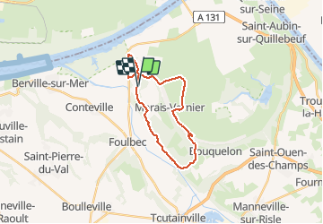

Length
20 km

Max alt
120 m

Uphill gradient
373 m
Km-Effort
25 km

Min alt
-1 m

Downhill gradient
375 m
Boucle
Yes
Creation date :
2018-09-11 09:12:35.217
Updated on :
2018-09-11 09:12:35.217
--
Difficulty : Unknown

FREE GPS app for hiking
 SityTrail
IGN / Geographical institutes
SityTrail Plus
The world is yours!
About
Trail Walking of 20 km to be discovered at Normandy, Eure, Saint-Samson-de-la-Roque. This trail is proposed by doudet.
Positioning
Country:
France
Region :
Normandy
Department/Province :
Eure
Municipality :
Saint-Samson-de-la-Roque
Location:
Unknown
Start:(Dec)
Start:(UTM)
313785 ; 5478261 (31U) N.
Comments