


Riom les vignes de ronchalon

jeanic63
User
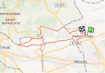

Length
8.4 km

Max alt
477 m

Uphill gradient
191 m
Km-Effort
10.9 km

Min alt
341 m

Downhill gradient
188 m
Boucle
Yes
Creation date :
2022-12-28 10:58:46.735
Updated on :
2022-12-28 11:00:07.85
2h29
Difficulty : Easy

FREE GPS app for hiking
 SityTrail
IGN / Geographical institutes
SityTrail Plus
The world is yours!
About
Trail On foot of 8.4 km to be discovered at Auvergne-Rhône-Alpes, Puy-de-Dôme, Riom. This trail is proposed by jeanic63.
Description
départ la chapelle saint don
Positioning
Country:
France
Region :
Auvergne-Rhône-Alpes
Department/Province :
Puy-de-Dôme
Municipality :
Riom
Location:
Unknown
Start:(Dec)
Start:(UTM)
507687 ; 5083440 (31T) N.
Comments