


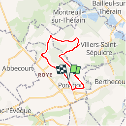
Ponchon _ La Pierre aux Fées _9,8km

Pousscailleux
User

Length
9.8 km

Max alt
147 m

Uphill gradient
158 m
Km-Effort
11.9 km

Min alt
78 m

Downhill gradient
157 m
Boucle
Yes
Creation date :
2014-12-10 00:00:00.0
Updated on :
2014-12-10 00:00:00.0
2h35
Difficulty : Medium

FREE GPS app for hiking
 SityTrail
IGN / Geographical institutes
SityTrail Plus
The world is yours!
About
Trail Walking of 9.8 km to be discovered at Hauts-de-France, Oise, Ponchon. This trail is proposed by Pousscailleux.
Description
Départ du nouveau parking du cimetière de Ponchon, rue des Faïenciers (GPS : N49°21'04" / E002°11'38")
Position du dolmen : N49°22'02" / E002°12'05"


Positioning
Country:
France
Region :
Hauts-de-France
Department/Province :
Oise
Municipality :
Ponchon
Location:
Unknown
Start:(Dec)
Start:(UTM)
441459 ; 5466806 (31U) N.
Comments