


Randonnée du 02/08/2019 à 12:08

geranimo
User
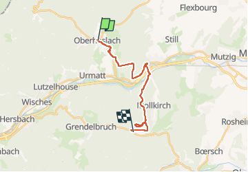

Length
16.1 km

Max alt
564 m

Uphill gradient
532 m
Km-Effort
23 km

Min alt
213 m

Downhill gradient
461 m
Boucle
No
Creation date :
2023-01-01 15:19:53.324
Updated on :
2023-01-01 16:08:18.349
5h12
Difficulty : Medium

FREE GPS app for hiking
 SityTrail
IGN / Geographical institutes
SityTrail Plus
The world is yours!
About
Trail Walking of 16.1 km to be discovered at Grand Est, Bas-Rhin, Oberhaslach. This trail is proposed by geranimo.
Positioning
Country:
France
Region :
Grand Est
Department/Province :
Bas-Rhin
Municipality :
Oberhaslach
Location:
Unknown
Start:(Dec)
Start:(UTM)
376772 ; 5378810 (32U) N.
Comments