


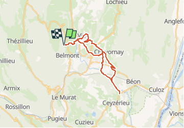
GTJ 09 Vogland-Culoz-Vogland

nicolas54230
User

Length
25 km

Max alt
531 m

Uphill gradient
675 m
Km-Effort
34 km

Min alt
234 m

Downhill gradient
673 m
Boucle
Yes
Creation date :
2023-01-01 17:16:30.43
Updated on :
2023-01-01 17:17:39.449
2h22
Difficulty : Difficult

FREE GPS app for hiking
 SityTrail
IGN / Geographical institutes
SityTrail Plus
The world is yours!
About
Trail Mountain bike of 25 km to be discovered at Auvergne-Rhône-Alpes, Ain, Valromey-sur-Séran. This trail is proposed by nicolas54230.
Positioning
Country:
France
Region :
Auvergne-Rhône-Alpes
Department/Province :
Ain
Municipality :
Valromey-sur-Séran
Location:
Belmont-Luthézieu
Start:(Dec)
Start:(UTM)
706104 ; 5085154 (31T) N.
Comments