


Etape 14

geranimo
User
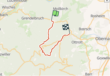

Length
14.9 km

Max alt
697 m

Uphill gradient
495 m
Km-Effort
22 km

Min alt
286 m

Downhill gradient
561 m
Boucle
No
Creation date :
2023-01-01 17:44:08.001
Updated on :
2023-01-02 18:02:24.124
4h55
Difficulty : Medium

FREE GPS app for hiking
 SityTrail
IGN / Geographical institutes
SityTrail Plus
The world is yours!
About
Trail Walking of 14.9 km to be discovered at Grand Est, Bas-Rhin, Mollkirch. This trail is proposed by geranimo.
Positioning
Country:
France
Region :
Grand Est
Department/Province :
Bas-Rhin
Municipality :
Mollkirch
Location:
Unknown
Start:(Dec)
Start:(UTM)
379266 ; 5372052 (32U) N.
Comments