GTJ 02 ST Hyppolite-Mandeure-St Hyppolite

nicolas54230
User
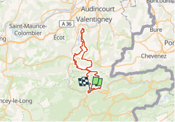

Length
55 km

Max alt
836 m

Uphill gradient
1617 m
Km-Effort
76 km

Min alt
345 m

Downhill gradient
1615 m
Boucle
Yes
Creation date :
2023-01-01 18:04:08.738
Updated on :
2023-01-01 18:09:22.251
2h30
Difficulty : Difficult

FREE GPS app for hiking
 SityTrail
IGN / Geographical institutes
SityTrail Plus
The world is yours!
About
Trail Mountain bike of 55 km to be discovered at Bourgogne-Franche-Comté, Doubs, Saint-Hippolyte. This trail is proposed by nicolas54230.
Positioning
Country:
France
Region :
Bourgogne-Franche-Comté
Department/Province :
Doubs
Municipality :
Saint-Hippolyte
Location:
Unknown
Start:(Dec)
Start:(UTM)
335370 ; 5243314 (32T) N.
Comments