


St COLOMBES

juanluco76
User

Length
9.9 km

Max alt
122 m

Uphill gradient
72 m
Km-Effort
10.8 km

Min alt
91 m

Downhill gradient
71 m
Boucle
Yes
Creation date :
2023-01-05 22:45:15.344
Updated on :
2023-01-05 22:46:46.837
2h27
Difficulty : Medium

FREE GPS app for hiking
 SityTrail
IGN / Geographical institutes
SityTrail Plus
The world is yours!
About
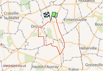
Trail Walking of 9.9 km to be discovered at Normandy, Seine-Maritime, Sainte-Colombe. This trail is proposed by juanluco76.
Positioning
Country:
France
Region :
Normandy
Department/Province :
Seine-Maritime
Municipality :
Sainte-Colombe
Location:
Unknown
Start:(Dec)
Start:(UTM)
338706 ; 5518499 (31U) N.
Comments