


le bonnet de calvin (le chatel)

maupassant38
User
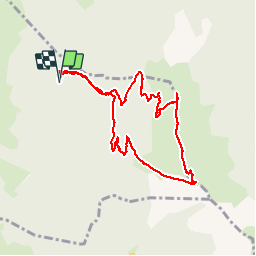

Length
9.5 km

Max alt
1932 m

Uphill gradient
656 m
Km-Effort
18.3 km

Min alt
1294 m

Downhill gradient
655 m
Boucle
Yes
Creation date :
2019-02-22 22:31:55.7
Updated on :
2019-02-22 22:31:55.719
3h49
Difficulty : Medium

FREE GPS app for hiking
 SityTrail
IGN / Geographical institutes
SityTrail Plus
The world is yours!
About
Trail Walking of 9.5 km to be discovered at Auvergne-Rhône-Alpes, Isère, Mens. This trail is proposed by maupassant38.
Positioning
Country:
France
Region :
Auvergne-Rhône-Alpes
Department/Province :
Isère
Municipality :
Mens
Location:
Unknown
Start:(Dec)
Start:(UTM)
720629 ; 4966937 (31T) N.
Comments
La boucle dans l'autre sens est peut-être mieux adaptée au terrain