


col de l'arzelier-sous les 2 soeurs

maupassant38
User
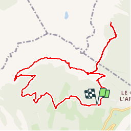

Length
12.6 km

Max alt
1623 m

Uphill gradient
522 m
Km-Effort
19.6 km

Min alt
1228 m

Downhill gradient
524 m
Boucle
Yes
Creation date :
2019-02-22 22:31:54.573
Updated on :
2019-02-22 22:31:54.59
2h59
Difficulty : Medium

FREE GPS app for hiking
 SityTrail
IGN / Geographical institutes
SityTrail Plus
The world is yours!
About
Trail Walking of 12.6 km to be discovered at Auvergne-Rhône-Alpes, Isère, Château-Bernard. This trail is proposed by maupassant38.
Positioning
Country:
France
Region :
Auvergne-Rhône-Alpes
Department/Province :
Isère
Municipality :
Château-Bernard
Location:
Unknown
Start:(Dec)
Start:(UTM)
703459 ; 4984854 (31T) N.
Comments