


Aurel .... avec Regis Vallon

raygautier
User
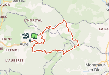

Length
19.3 km

Max alt
1247 m

Uphill gradient
968 m
Km-Effort
32 km

Min alt
445 m

Downhill gradient
965 m
Boucle
Yes
Creation date :
2023-01-05 07:33:50.0
Updated on :
2023-01-11 10:26:10.703
5h14
Difficulty : Very difficult

FREE GPS app for hiking
 SityTrail
IGN / Geographical institutes
SityTrail Plus
The world is yours!
About
Trail Walking of 19.3 km to be discovered at Auvergne-Rhône-Alpes, Drôme, Aurel. This trail is proposed by raygautier.
Positioning
Country:
France
Region :
Auvergne-Rhône-Alpes
Department/Province :
Drôme
Municipality :
Aurel
Location:
Unknown
Start:(Dec)
Start:(UTM)
682633 ; 4951755 (31T) N.
Comments