


220929_Portes

fario
User
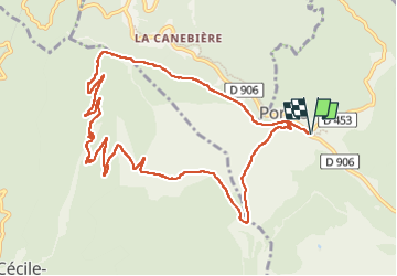

Length
12.2 km

Max alt
619 m

Uphill gradient
334 m
Km-Effort
16.6 km

Min alt
368 m

Downhill gradient
335 m
Boucle
Yes
Creation date :
2023-01-08 17:22:38.602
Updated on :
2023-01-08 17:22:38.602
4h54
Difficulty : Difficult

FREE GPS app for hiking
 SityTrail
IGN / Geographical institutes
SityTrail Plus
The world is yours!
About
Trail Walking of 12.2 km to be discovered at Occitania, Gard, Portes. This trail is proposed by fario.
Description
Randonnée toujours très agréable
Photos


Positioning
Country:
France
Region :
Occitania
Department/Province :
Gard
Municipality :
Portes
Location:
Unknown
Start:(Dec)
Start:(UTM)
581847 ; 4902165 (31T) N.
Comments