


lac

trailer38
User
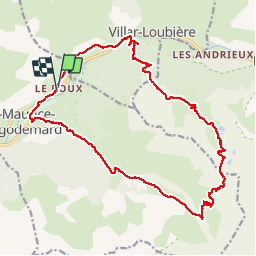

Length
22 km

Max alt
2432 m

Uphill gradient
1580 m
Km-Effort
43 km

Min alt
941 m

Downhill gradient
1584 m
Boucle
Yes
Creation date :
2014-12-10 00:00:00.0
Updated on :
2014-12-10 00:00:00.0
6h36
Difficulty : Unknown

FREE GPS app for hiking
 SityTrail
IGN / Geographical institutes
SityTrail Plus
The world is yours!
About
Trail Other activity of 22 km to be discovered at Provence-Alpes-Côte d'Azur, Hautes-Alpes, Saint-Maurice-en-Valgodemard. This trail is proposed by trailer38.
Positioning
Country:
France
Region :
Provence-Alpes-Côte d'Azur
Department/Province :
Hautes-Alpes
Municipality :
Saint-Maurice-en-Valgodemard
Location:
Unknown
Start:(Dec)
Start:(UTM)
271716 ; 4966171 (32T) N.
Comments