


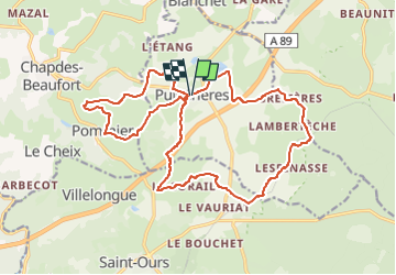
Pulvérières -Lespinnasse -Fraisse -Montcogniol 21 km

jeanic63
User

Length
21 km

Max alt
891 m

Uphill gradient
389 m
Km-Effort
26 km

Min alt
763 m

Downhill gradient
393 m
Boucle
Yes
Creation date :
2023-01-10 09:52:03.019
Updated on :
2023-01-10 09:56:27.274
5h51
Difficulty : Medium

FREE GPS app for hiking
 SityTrail
IGN / Geographical institutes
SityTrail Plus
The world is yours!
About
Trail On foot of 21 km to be discovered at Auvergne-Rhône-Alpes, Puy-de-Dôme, Pulvérières. This trail is proposed by jeanic63.
Description
départ Pulérières vers l'ecole
Positioning
Country:
France
Region :
Auvergne-Rhône-Alpes
Department/Province :
Puy-de-Dôme
Municipality :
Pulvérières
Location:
Unknown
Start:(Dec)
Start:(UTM)
493011 ; 5081414 (31T) N.
Comments