


Xonrupt longemer

lepompi
User
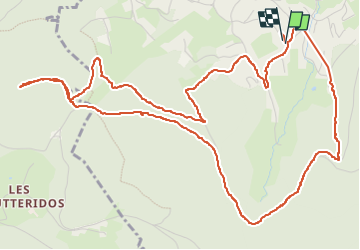

Length
7.3 km

Max alt
987 m

Uphill gradient
253 m
Km-Effort
10.6 km

Min alt
758 m

Downhill gradient
254 m
Boucle
Yes
Creation date :
2023-01-10 08:05:29.174
Updated on :
2023-01-10 10:37:06.471
2h31
Difficulty : Medium

FREE GPS app for hiking
 SityTrail
IGN / Geographical institutes
SityTrail Plus
The world is yours!
About
Trail Walking of 7.3 km to be discovered at Grand Est, Vosges, Xonrupt-Longemer. This trail is proposed by lepompi.
Description
de petites montées pour rejoindre pistes skl de fond
Photos

Positioning
Country:
France
Region :
Grand Est
Department/Province :
Vosges
Municipality :
Xonrupt-Longemer
Location:
Unknown
Start:(Dec)
Start:(UTM)
345416 ; 5326603 (32U) N.
Comments