


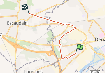
GRP BM6 - modification denain à Escaudain

dehemjacques
User

Length
4.6 km

Max alt
42 m

Uphill gradient
24 m
Km-Effort
4.9 km

Min alt
31 m

Downhill gradient
24 m
Boucle
No
Creation date :
2023-01-11 11:52:28.249
Updated on :
2023-01-11 11:52:32.193
1h07
Difficulty : Easy

FREE GPS app for hiking
 SityTrail
IGN / Geographical institutes
SityTrail Plus
The world is yours!
About
Trail Walking of 4.6 km to be discovered at Hauts-de-France, Nord, Denain. This trail is proposed by dehemjacques.
Positioning
Country:
France
Region :
Hauts-de-France
Department/Province :
Nord
Municipality :
Denain
Location:
Unknown
Start:(Dec)
Start:(UTM)
526944 ; 5574486 (31U) N.
Comments